Flash floods hit the Dallas-Fort Worth area overnight Monday, with flooded streets necessitating rescue efforts as photos showed abandoned cars floating on the streets. In some areas, rainfall totals would be considered a 1-in-1,000-year flood.
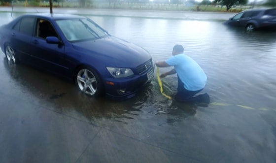 |
| IMAGE CREDIT-www.nbcnews.com |
Continued rain continues in and around Dallas; Some rain gauges in the area have recorded more than 10 inches so far. Dallas-Fort Worth International Airport also recorded a record-breaking 3.01 inches of rain in one hour.
The National Weather Service in Fort Worth warned of a continued risk for “life-threatening flash flooding”, extending its flash flood warning in and around Dallas County until 1 p.m.
Central Time. As per the warnings, it has rained at least 10 inches, with 2 to 4 inches left. The risk of flood damage is “considerable”, it said, warning residents not to drive on flooded roads and move to higher ground immediately. A flash flood warning has also been issued for Fort Worth and Canton, Tex.
In a few isolated cases, rainfall would qualify as a 1-in-1,000 interval flood. The torrential rains marked the latest such flooding that has occurred across the United States in the past few weeks. In one week alone, there were three 1-in-1,000-year rain events – flooding in St. Louis, eastern Kentucky, and southeastern Illinois.
While controversial, the term is used to describe a rainfall event that is expected to occur once every 1,000 years, meaning that the probability of it occurring in any given year is only 0.1 percent.
Human-driven climate change has increased the frequency of such high rainfall events – a warmer atmosphere, capable of holding more moisture, can produce heavy rains. According to the 2022 report by the Intergovernmental Panel on Climate Change, the rate of extreme rainfall events that cause severe flooding is expected to increase in the future.
Fox Weather reporter Robert Ray, who was reporting floods in Dallas, found himself rescuing a woman who had accidentally walked into a flooded intersection.
“He literally, as I was setting up for the shot here, guys, pulled in and didn’t feel it,” Ray told Fox Weather. “Next thing you know, his car was floating. So, I went over there and tried to push his vehicle as hard as I could.”
Several water rescue operations were underway Monday in the Dallas-Fort Worth area. Jennifer J., a spokeswoman for the city’s Office of Emergency Management. According to Moreno, as of 8 a.m. local time, Dallas Fire and Rescue had responded to 141 water-related emergencies. As of 10 a.m., the Fort Worth Fire Department was responding to 25 high water rescue calls, and Dallas Police were responding to an additional 43 “high water calls.”
Harris County, Tex. meteorologist Jeff Lindner noted on Twitter that a weather gauge recorded about 40 percent of its normal annual rainfall in just 12 hours.
Later on Monday morning, the same gauge received over 14.9 inches of rain, still within 12 hours.
Such rates of precipitation are nearly impossible for soils – not to mention impenetrable paved surfaces – to absorb without runoff that can cause flash floods.
The water level in the Trinity River in Dallas is expected to enter a minor flood phase Monday through Tuesday. Flooding is also occurring in Balch Springs, a suburb of Dallas, where grass fires damaged more than two dozen homes earlier this summer.
A communications outage due to a Verizon line problem has prevented the National Weather Service from issuing a warning from the Fort Worth office, the NWS confirmed to the Washington Post, though the office says it has yet to stay on top. Working closely with partner offices. Flooding
“While Verizon works to fix this issue, long- and short-range forecasts, and warnings for Dallas-Ft. price zones are seamlessly delivered via service backup by our forecast offices in Nashville, Tennessee, and Norman, Oklahoma. continues to drop out,” said NWS director of public affairs Susan Buchanan.
After the flooding rains have left the Dallas area, they are expected to continue tracking along Interstate 20 toward areas such as Shreveport and LA. The National Weather Service’s Weather Prediction Center has issued a moderate risk of extreme rainfall for northeastern Texas and northwestern Louisiana. , 3 to 5 inches of rain is expected in the area and 2 to 3 inches of rain is possible per hour.
More rain is expected on Tuesday with a moderate risk of heavy rain in parts of Alabama, and northern Louisiana.
Before Monday’s heavy rain, the Dallas-Fort Worth area was in the grip of a major drought.
Heavy rainfall in Texas, Arkansas, Louisiana, and Oklahoma results from extreme moisture overlap and a coercive triggering mechanism.
Over the weekend, a heavy tropical system moved ashore in northern Tamaulipas, Mexico, with relatively little fanfare. Its direct impact was minimal, but it scorched deep tropical moisture-laden air masses.
The PWAT, or precipitated water index — a measure of how much moisture is present in a column of air from the bottom of the atmosphere to the top — is approaching a remarkable three inches.
That wind is blowing north with thunderstorms and turning into heavy rain with a stable front. Head west to east toward the Arkansas-Louisiana border near Oklahoma’s Red River.
A low-pressure wave that is forming in front and spreading towards the east will further increase the rainfall. Low-end tornado risk will also be visible in some places.
When flooding occurred in the Dallas area, a flood alert was raised in parts of north-central and northeastern Texas — an alert level that is below a flood warning — on mid-Monday, including Dallas, Rockwall, and Delta counties.
SOURCE: THE WASHINGTON POST